This is the second part of the raw results from the first annual Timberline Trail survey. To see the first set of results please see here. This is the rest of the raw data from the survey.
How would you rate the difficulty of traverses?
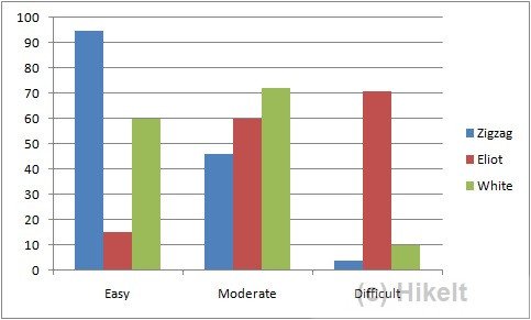
Unfortunately, I wish I had added other traverses to the list. So an improvement for next year! In particular, it would have been interesting to include the Sandy, which for many folks is a bit of a climb if they go counter-clockwise. Also, the phrasing of this question was probably a little misleading. The intent was more on the physical stress of the traverses. So for example coming out of Zigzag Canyon is about a 1000′ gain and can be quite tiring. Given how I worded the question there is little surprise that the Eliot was ranked as the hardest traverse. And clearly, the final descent and ascent that needs ropes occasionally can be somewhat intimidating.
Which of the following was an issue for you?
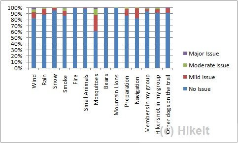
This was a pretty broad category of questions that explored which typical hiking issues were an issue. This covered everything that was not medical related, from weather to animals, to hiking buddies. The good news is the vast majority of hikers had a pleasant hike with very few issues. This year the summer was very favorable for hiking.
Although there were not many issues reported – the biggest issue was with mosquitoes. With about 40% of people reporting at least some issues with them. Wind and rain were an issue for some folks – I assume this is related to a few specific days. Outside of that, preparation and navigation followed as being an issue for around 15% of people.
Although there were a few issues reported as being major; they broke down as Wind(5), Mosquitoes(4), Smoke(3), Other Dogs (3), Members in my group (2), Rain (1), and Hikers not in my group (1).
I have a particular interest in the feedback around dogs, partly because I often hike with Hunter, and hiking with dogs is a topic that elicits a visceral reaction in the hiking community. However, the feedback from this survey is that the vast majority of hikers have no issues with dogs on the trail.
What kind of shoes did you wear?
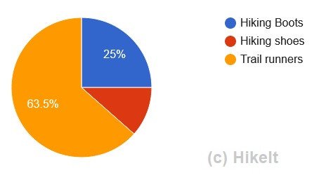
Back to the simple stuff. There has been a general trend for lighter footwear in the hiking community. This is echoed by the results from the survey where almost 2/3rds of the hikers are now hiking in trail runners and only a 1/4 in traditional hiking boots. There has always been the discussion of whether you get enough ankle support from trail runners but this seems to be offset by them being lighter weight and often leading to fewer foot problems like blisters.
Did you take trekking poles?

No real surprise that most people are taking two trekking poles. These provide good stability and are almost essential for a longer hike. There are a few people who hike with a single pole (and I often will) but this might be because only one hand is free and the other is used, for example, to hold onto a dog leash. And a few folks are hiking without poles. Later on, I’ll see if there is a correlation between age and hiking without poles – is this perhaps something that the younger hikers do?
Did you take crampons? / Did you take microspikes?
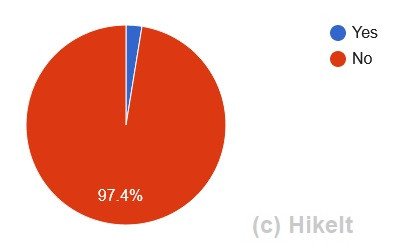
These two questions are related to snow preparedness. There was quite a lot of snow on the trail until mid-July. Despite this, no one took crampons with them. There were a few people who took microspikes. I’ll also verify this but I suspect these were people who left relatively early in the season and as soon as reports were available that the trail was snow-free, everyone left their microspikes at home.
Of course, having microspikes does not necessarily mean that they were used and so there is also a little ambiguity in this question as well.
Did you take bear spray?
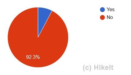
It’s pretty much said that the black bears on Mount Hood are timid and will avoid you. In all the years I have been hiking on the mountain I have yet to see a bear on a hike. I have seen evidence of bears and seen a couple down in Rhododendron – but not on the mountain itself. For most folks carrying bear spray is considered unnecessary.
Despite this, just under 10% of hikers still carried bear spray. There may be a possibility that some hikers are bringing bear spray as general protection – that might be a correlation to look at later. However, it’s worth noting from the above, that only one person noted an issue with a bear and this was mild.
What food storage method did you use?
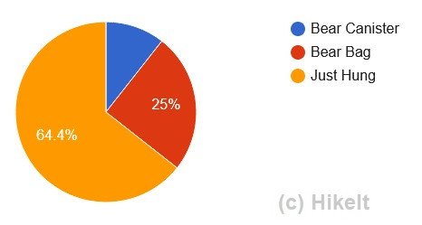
Related to bringing bear spray is how you hang your food. Again generally hangs are considered more of a critter hang than a bear hang – although there are clearly bears around the trail and so taking more a precaution with food to prevent it from being pilfered by bears would be advisable.
About 10% of hikers took bear canisters. Although these are great for bear protection they are heavy and can add just under 3lbs to your pack weight. Bear bags, such as Ursacks, make a great alternative. However, the majority of hikers are just hanging their food. However, a good clarification would be a bear hang versus just a critter hang.
Navigation Support
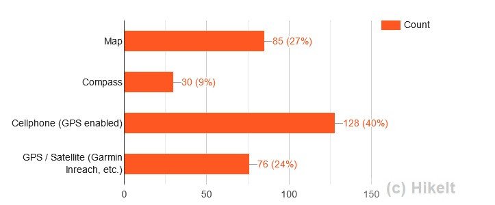
Possibly the most surprising result from the entire survey was navigation support. Map and compass have always been part of the 10 essentials. Although there are additional great navigation aids available, with phones and GPS devices, having a map and compass (and being able to use them) is always advisable as a backup. And when everything goes well, the Timberline Trail is not hard to follow, I was surprised by the lack of a map and compass with many hikers.
With a total of around 150 respondents – the majority are using a cell phone for navigation with only just over 50% actually carrying a map with them and only about 20% bringing a compass with them. There are quite a few groups traveling and so it may be the case that they only have a single map and compass per group.
Who is your cell carrier?
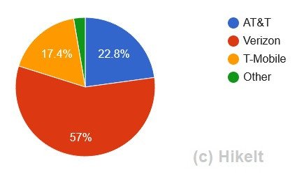
Cell coverage is improving around Mount Hood. There are many places that have excellent coverage around the ski resorts and also in the line of sight of some of the towns. This question will need a little more analysis, in particular, which carriers provide the better service.
Verizon was clearly the most popular carrier, with the rest being pretty evenly split between AT&T and T-Mobile. These are the three big carriers that also have their own independent network of towers. Anyone who is in the other ‘other’ category is most likely using service provided by one of the major three carriers.

In terms of coverage, the majority of hikers found that they had coverage for around 1/3rd of the hike, although there were some that considered themselves to have coverage over 2/3rds of the time. I’ll look at breaking this down by carrier in the future so that we can see which of the carriers provides the best service around the whole of the Timberline Trail.
Also as technology improves there are a number of new developments that might make communication easier. Historically satellite communications had been only in the realm of such devices as Garmin’s. However, recently Apple announced that their new series of iPhones will be enabled with satellite communication for emergencies and no doubt as this technology improves it will slowly include more ways of communicating.
There’s still more raw data to analyze so I’ll be including a final series with the rest of the raw data from the first annual Timberline Trail survey results.


Trackbacks/Pingbacks