

Paradise Park Trail

I love going up to Paradise Park, and the Paradise Park Trail is one of my favorite trails on Mt. Hood. I’ve written many times about my adventures to Paradise Park, whether by the Paradise Park Trail or the Timberline Trail. During summer this is an especially popular part of Mount Hood. Making the hike in the early hiking season is a real gem. At this time of the hiking season there is always the risk of snow on the trail and it is certain that Paradise Park itself will still be snow bound. Often in many years the snow does not melt out until the middle of July.
The trailhead itself is off the Kiwanis Camp Road. Be prepared for a good exercise as it is about 6 1/2 miles form the trailhead to Paradise Park, with an elevation gain of around 3000 feet. The trailhead has moved recently and is now well equipped with a portable-potty and trash can. This is a fee area so you’ll need a day pass, or similar (I have a NorthWest Forest Pass), between May 1st and October 31st.
I headed out on this adventure, with Hunter, on June 7th.
The Lower Trail

The start of the trail is quite gentle as it runs along side the Zigzag River. After maybe 1/2 a mile it reaches the permit box, which currently had no permits in it. At these lower elevations the Rhododendrons are just starting to bloom, but only at these lower elevations. Being a beautiful and warm day, the fresh scent of pine from the moist duff drifted through the air – an aphrodisiac to any hikers mind.
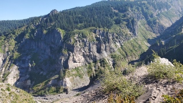
After the permit box, the trail starts a series of short switchbacks. This provides a good little work out an elevation gain. However the trail quickly levels out to a gentle rise as it follow the ridge of the northern ridge of Zigzag canyon. After just over two miles there are a few viewpoints across Highway 26, towards Mirror Lake and Tom, Dick and Harry.
Surprising the traffic noise from the highway is loud. Even so, this make a great spot for a quick water break. After our quick break, we resumed hiking, along the ridge line. Some points start to get a little steeper, but it is a while before the scenery changes from hiking within the trees.
The Middle Trail

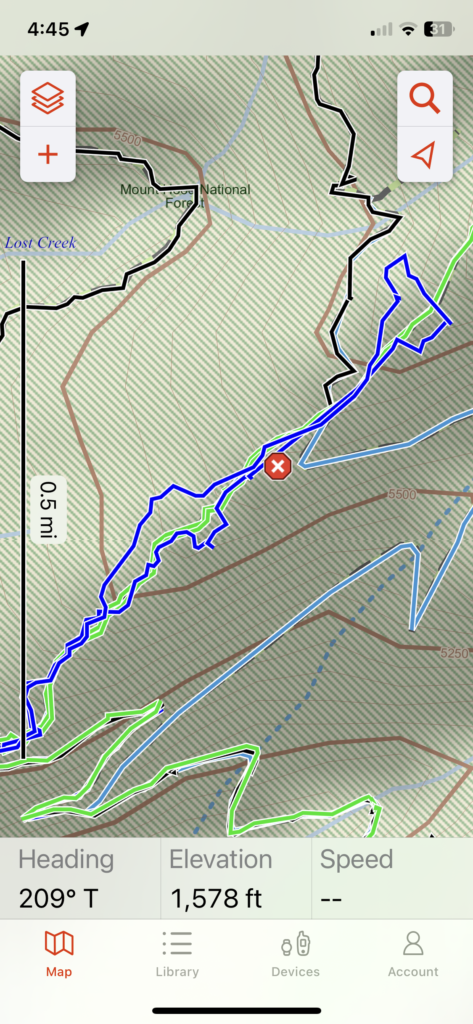
Switchbacks start again and the trail crosses a creek on a wooden bridge. Some small patches of snow started to appear at around 4200 feet. However these were few and far between . By the time the trail crossed back over the creek at about 4800 feet the snow had become more continuous. At this point you really need to be comfortable in trail finding and snow navigation as it is very easy to loose the trail. So far, in about the first four mile, we had met 3 people and now we were in the snow was not much of a boot track. By the time the trail intersects the Zigzag Mountain Trail we were deep in snow.
It’s amazingly hard trail signs when you can’t see the trails. Navigation has become much easier with cell phones – but this is not the time to be relying on a single device – in addition to my phone, I have a GPS watch, Garmin InReach and a map and compass. If you are going to tackle this trail when it is still snow covered be sure you’re comfortable with this level of navigation. Currently the snow is pretty firm and there was no real need for either snow shoes or spikes.
Of course the joy of this trail, especially at this time of year is the peace and tranquility. You can be almost entirely alone.
The Upper Trail
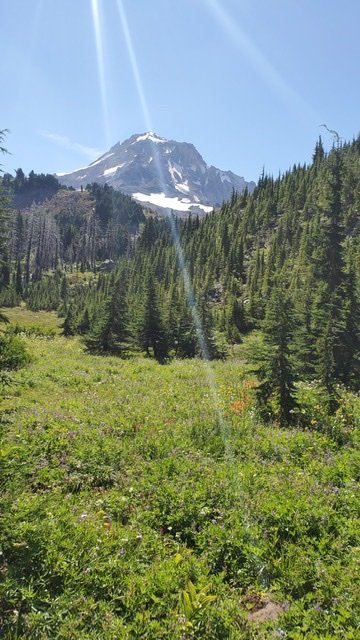
From the intersection of the Zigzag Mountain Trail, which is at just over 5000 feet, the trail rises in almost a straight line – in the snow you can make some short cuts). It intersects the Timberline Trail – where it descends down into Zigzag canyon, or heads towards Ramona Falls. From here the trail continues up, through deeper snow, to around the intersection of the Paradise Park Loop trail. As you follow this part of the trail slowly the trees thin and Mt. Hood starts to loom large in front of you.

Paradise Park is as wondrous in the snow as it is when it is blooming with wildflowers. The crystalline view of Mount Hood, dressed in ice and snow, set against the vivid blue background makes for the perfect backdrop. Hunter had a dog of a time; firstly relaxing in a small grassy spot and then playing in the snow. Made it all worth the hike for him. Of course he took a moment to pose for a headshot.


The Aftermath
Heading back down always seems quicker – there is a boot track in the snow to follow – so the navigation. is a lot easier and the soft duff path under our feet made for a quick return to the trailhead. All in all about a 14 mile round trip with about 3000 of vertical elevation gain.
Unfortunately, somehow on the way down, my Garmin InReach came off of my backpack. I have no idea how this happened, but when we were back at the trailhead, it was not. Luckily it is a satellite communicator – so I spent some time in the evening asking for it to locate itself to see approximately where it was. I did this a couple of times to make sure it was accurate and then plotted the co-ordinates on Garmin Explore.
Of course it was almost at the top of the route, just where the trees open up into Paradise Park. To valuable to leave – and of course the irony of it being attached to my LNT card – I steeled myself for another trip up to Paradise Park the next morning. I pretty much followed the same route – without Hunter – it all seemed so familiar that the journey was that much quicker. As I got into the snow zone, I navigated to the co-ordinates I had retrieved the previous evening. With just a little bit of searching – there it was – my Garmin just lying in the snow.
Happy to have found it – but adding another 14 mile hike onto the previous day was definitely exhausting!

Conclusion
Paradise Park Trail is great anytime of year – it’s one of the quieter ways to reach Paradise Park. In the early season it leads you straight up without having to worry about traversing down into Zigzag canyon (and out again). While the snow level is still hovering around 5000 feet – you’ll need some navigation skills and a comfort level for hiking on snow.
- Start: Paradise Park Trailhead, Kiwanis Camp Road
- Trails: Paradise Park Trail #778
- Start Elevation: 2742
- End Elevation: 5828
- Total Distance: 14.4 miles


