
I’ve hiked the Paradise Park Trail a few times. It’s rapidly becoming one of my favorite hikes on Mount Hood. It’s a pretty strenuous hike, climbing about 3000′ over 6 miles. But it takes you through some stunning scenery that changes from covered forest all the way to stunning views of Mount Hood. It’s also a pretty quiet trail, even though it’s not the shortest route to get to Paradise Park, it’s nowhere nearly as busy as the route from Timberline Lodge. Given the relatively high snowpack this year I assumed that there would be snow on the trail – so I came prepared with microspikes if necessary. I’ve done this in late summer when the flowers are in bloom. This trip was relatively early for a high snow year – so I was expecting some challenges.
The Trail Head

Kudos to the Forest Service. They have completely redone the trailhead. The trailhead is off Kiwanis Camp Road and is now a large graveled area on the left side of the road. It’s complete with enough parking for around 30 cars, a picnic table, a trash can, and a porta-potty. This is a massive improvement from the cramped spot a few hundred yards further north. The old entrance to the north is now gated off – although there is a little roadside parking. This area is a fee area and so you will need either a day pass or an equivalent fee area pass. Another improvement from the Forest Service – you can now buy day passes at the trailhead through your cell phone.

I’ve seen that at other fee-use areas but I assume you need to have cell service so it may not work everywhere. But all you have to do is scan the QR code, add your license plate and pay the fee. However, the Northwest Forest Pass also works well!
From the trailhead, the trail follows the road for a short while before it meets up with the old trailhead. Here it turns left and crosses a gated bridge over the ZigZag river. We’re now on the west side of the ZigZag and will follow the west ridge of the ZigZag canyon all the way up to Paradise Park.
Lower trail
The first 0.5 mile or so is relatively flat and has some good camping spots, especially between the trail and the river. Some of these are large and would make great group sites. The start of the trail is at about 2900′.
As you enter the wilderness area there is a standard Forest Service permit box – this is currently unfilled – so even though you are supposed to self-permit here – it’s currently not possible. I’ve noticed that at quite a few permit boxes this year.
Shortly after starts a series of switchbacks that climb fairly steeply. However, the trail is wide and Rhododendrons bloom all around. This part of the trail is well maintained although there are a few blow-downs to navigate around.
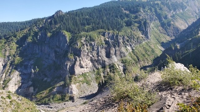
After about 2.5 miles and a 1000′ of elevation gain – there are some opportunities to look over the ZigZag canyon. These look out towards Tom Dick And Harry, and Skibowl. It’s now clear that the ZigZag river is well below and we are climbing high in the canyon ridge.
The trail continues on its rise – there are now no switchbacks but a continuous rise. The trail is soft underfoot and well covered from the sun.
Blowdown section

After about 4 miles, there is a section that navigates through an extensive blow-down section. This has been well cleared but the sheer number and size of the blow-downs are impressive. This is in stark contrast to the lower section of the trail which is a joy to hike through.
Through the blow-down section, there is far less canopy protection from the sun, and the temperature is noticeably higher.
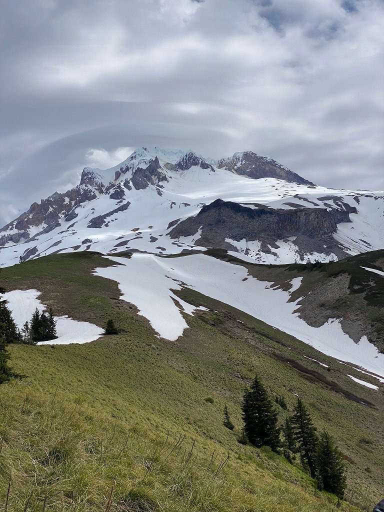
This section starts at about 4500 feet and ends at about 5200 feet. At the top of the section were the first patches of snow on the trail. There are also the very first glimpses of Mount Hood.
From the top of this section to the ZigZag Trail junction, the snow increases. The ZigZag Trail junction is about 5.5 miles in. From this point, the trail was completely snow-covered. It’s about another 0.5 miles to the junction with the Timberline Trail. The actual junction is completely under snow. However, the lookout over the ZigZag Canyon and the Timberline Trail down into ZigZag Canyon were snow-free.


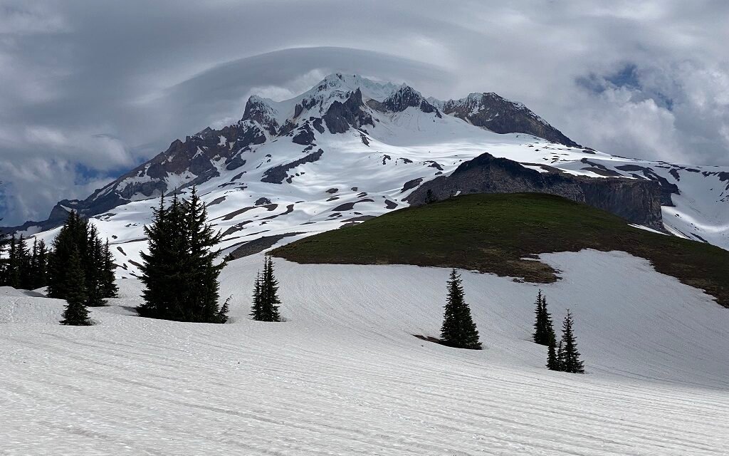
Paradise Park
From the Timberline Trail junction to the Paradise Park Loop Trail Junction is about another 0.5 miles. This is the official end of the trail and is now 6.5 miles from the trailhead at an elevation of about 5700′. Even though the trail is completely snow-covered navigation was pretty simple as this is just a straight shot up towards Mount Hood.
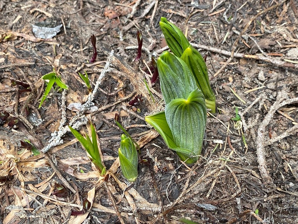
After the intersection with the Paradise Park Loop Trail, the views really open up. We were basically on the Paradise Park meadows – but there must have been at least 5′ of snow covering most of it. Buds and new shoots were just starting to peek out from the edges of the snow – but the beautiful flower shows are still a long way away.

Paradise Park was a joy! Large open expanses of snow with incredible views. We just wandered around for while taking in the experience. Overall the snow was easy going for the uphill climb – but for the descent, I decided to add microspikes for added traction. With the current snow conditions, snow shoes would seem unnecessary as the snow is pretty firm and there was pretty much no post-holing.
There were several tracks through the snow – it looked like several folks had been up the Paradise Park Trail and a couple had been along the Timberline and Paradise Park Loop Trails – although we couldn’t see for how far.


I would recommend something more waterproof than summer trail runners if you are hiking in snow. I should have worn my Altra RSMs which are more waterproof. Of course, snow navigation is a bit more difficult than just following a trail and so it’s also good to have some confidence in navigation off-trail. For this trip, I brought both a GPS device, a Mount Hood map and compass, and my cell phone. It’s worth noting that for all of this trip there was relatively good cell phone coverage – presumable because there is almost a direct line of sight to Skibowl area.
The Paradise Park Trail is a great way to access Mount Hood. It’s less crowded and takes you through some great areas.
Statistics
Round Trip Distance: 14.2 Miles
Max Elevation: 5837 feet
Min Elevation: 2826 feet
Difficulty: Difficult
Dog Friendly: Yes
Fee Required: Yes, Forest Service Day Pass or annual pass

