
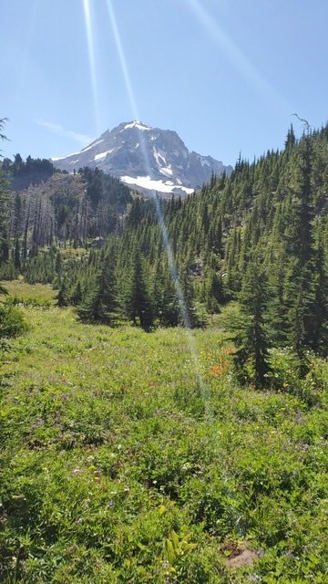
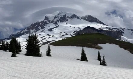
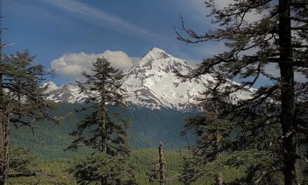
One of the most iconic trails in Oregon is the Timberline Trail around Mount Hood. Spectacular views, deep canyons, meadows, and challenging river crossings await those who take this route. This approximately 40-mile trail takes most backpackers 3-4 days, although there are plenty of folks who trail run the entire distance in a single day.
For most folks, the Timberline Trail journey starts at Timberline Lodge and goes in a clockwise direction, until arriving back at Timberline Lodge. This is the common direction and starting point. However, there are a lot of reasons to consider other starting points and directions. Last year I hiked exactly this route and so this year I decided to go in a counter-clockwise direction.
Note the windstorm of 2020 caused some of the Timberline Trail to be closed. Here are some suggested alternate routes.
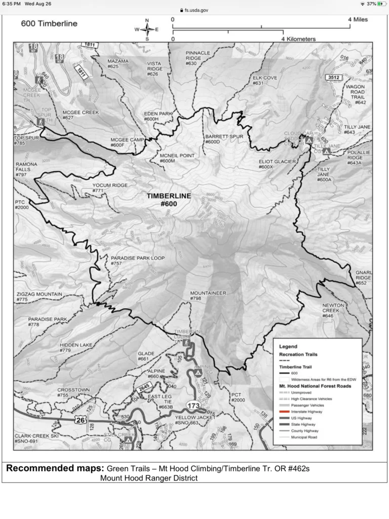
Starting Point
I decided to start again at Timberline Lodge. The main reason for this is it’s super convenient to get there and super easy to park, with simple access to the trail. However, there are several options for different starting points:
- Timberline Lodge
- Ramona Falls
- Top Spur
- Cloud Cap
Possibly the biggest impact in selecting the starting point and the direction is the order in which you’ll get to cross rivers. I think one of the advantages for a beginner to take the traditional route is that the first couple of river crossings are quite easy, the Zig-Zag and Sandy, and the harder ones are later. This gives you an opportunity to decide how comfortable you are with the river crossings. Counterclockwise the White, Clark, and Newton are generally a little more challenging.
Planning for the Trip
There are several aspects to planning any hiking trip. My backpacking gear is predominately set and is the same as what’s listed here. The major difference is in food preparation. It is really not necessary to take a bear canister on this trip. That makes the load a little lighter – it’s only necessary to hang food in Mount Hood National Forest. Food planning is still important – on this trip we would be gone for three nights and there would be three of us (and one dog) so in all that would be over 9 meals.
A great map for this trip is Green Trails Mount Hood Climbing Map. These used to be available at REI and Amazon – but more recently seem to have become a little harder to come by. However, it’s generally a great map for both the Timberline Trail and hiking close-in to Mount Hood.
One of the positive aspects of the Timberline Trail is there are multiple bail points if necessary. Starting at Timberline Lodge you can easily leave the trail if necessary at Cloud Cap, Top Spur, or Ramona Falls, and indeed if necessary there are a few other exit points along exit trails. This helps in having a backup plan if needed.
Weather – planning for the conditions
Its always critical to understand the predicted weather. A great site for this is NOAA site. This is very accurate and allows you to see variations in the predicted weather on different sides of the mountain. The rather forecast for Thursday thru Sunday (August 21st – 24th 2020) was reasonably good except for Friday night which had a 40% chance of rain on the west side of Mount Hood and 30% on the east side, starting at about 5 pm. Friday looked to be pretty cool.
Because of this forecast, this was definitely a trip I would definitely need to take my rain gear – which is just a pair of Frogg Toggs.
River Crossing – the most dangerous element
The river crossings around Mount Hood are potentially the most dangerous element of this hike. Several unfortunate hikers have died in the high waters. In recent years the National Forest Service has decided not to put any bridges over the rivers, I believe, since the death of Sarah Bishop in 2004. This means hikers must be able to understand how to cross glacial streams and understand both what impacts the rivers and their own abilities. Mount Hood National Forest has a published guide and you can see the same posters at various locations.
Safety in crossing the rivers depends on the time of year and the time of day, the rivers are primarily driven by snowmelt. They are usually lower in the morning than in the afternoon. Later in the season, they are generally milder after the majority of the snowmelt has gone. Thunderstorms can make a rapid and dramatic difference to the water height.
There are generally three ways to cross the streams:
- Logs – often there are downed logs that you can cross. Some of these can be large and easy crossings while others can be thin or multiple logs together. Generally a little bit of balance is required.
- Rock Hopping / Jumping – when they are lower, many of the streams can be crossed by either simply leaping across at the appropriate place or hopping across several rocks
- Walking – while generally the other two methods keep your feet dry, if there is not a safe log or rock hop, then walking through the river might be the only alternative. Remember that the rivers are cold, surprising swift and can be deeper than expected. Poles are essential.
Finally, if you don’t feel comfortable with any of these – either wait until the morning and see if the water level has dropped or backtrack – don’t risk a crossing you don’t feel comfortable with.
Final Considerations
I took Hunter on this hike – you can find out more about hiking with dogs here.
I’ve done this trail before – so I know there are plenty of good campsites – it’s not really necessary to pick a specific destination location each day. So I planned the itinerary to be roughly Timberline Lodge to somewhere between Meadows and Newton Creek, then on to Elk Cove area and then around Ramona Falls and finally back to Timberline Lodge. This is pretty much the reverse of the last trip I took.
Actual Trip Details
Timberline Lodge to Elk Cove
Elk Cove to Ramona Falls
Ramona Falls to Timberline Lodge
Viewranger Data
You can find this hike and download the route here.
Here’s the 3D Flyover of this route.

