
As we get into the shoulder and winter season, I see a lot of questions about how to determine what the hiking or backpacking conditions are like. Here is a set of resources that I use around Mount Hood. Some of them apply everywhere and some have associated resources in other locations.. Hopefully some of these will help in checking weather conditions.
- Call the local ranger station. This is probably the best piece of advice. The local ranger station will likely have the latest conditions and information. They can answer a whole plethora of questions – not just related to the conditions, but also around permits and trail conditions.
- To check the weather I use weather.gov. This is the source data used by many commercial sites – but this seems to have the most accurate and timely information that can be pinpointed to a couple of square miles.
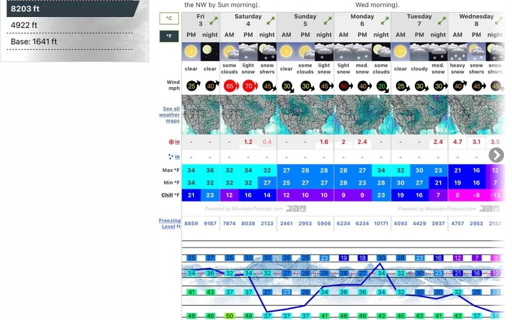
- For mountain conditions I like mountain-forecast.com. This is great for getting detailed forecasts around Hood , from the summit to the base.
- If you like a visual look, then you can check out the ski resort webcams at Timberline, Meadows and Skibowl. There are also a couple of webcams lower down the mountain operated by UO that can be accessed here.
- If you like a relatively live satellite picture (updated every few days) – the Sentinel Project from the European Space Agency is great. You can change the date so that you can see the historic conditions. I used this extensively in planning my JMT hike. Of course for Mount Hood in winter this will often be cloudy.
- Of course there are plenty of Facebook groups that can also give very recent trip reports. Timberline Trail – Mt. Hood and Oregon Hikers & Climbers are good resources.
Let me know in the comments if you use any other resources for checking weather conditions.


